Showing posts with label history. Show all posts

Friday, July 12, 2013

Historic Cumberland Maryland Part One

Hi all!
I'm spending a few days north of my usual mountain home, taking a much-needed break from the daily grind. I'm so far "out there" I don't have data service on my phone!  I'm in beautiful and historic Cumberland Maryland, about 3.5 hours north-northwest of Crozet Virginia.  Cumberland lies in the Appalachian/Allegheny mountains and is both beautiful and charming.  There is still that "small town" feel to it and in the neighboring town of Frostburg.  I have taken so many pictures to share with you but as of right now I don't have a connection on my phone to upload them.  I do promise to write a part two to this blog post as soon as I'm back home and online again.  (I'm on a friend's laptop with an ethernet connection and I don't want to go rearranging his internet protocols) Anyway, I found a great page online from the National Park Service that talks about the history of this area and there are some very cool photographs there too.


CUMBERLAND TODAY

Photo by Carter and Roque

You can link to the page HERE and I'm posting excerpts below.

The following is from the NPS.gov page about the history of Cumberland Maryland.  No copyright infringement intended.  Used for informational, educational, and historic purposes only.

HISTORY OF CUMBERLAND MARYLAND
Baltimore St., early 1900s
Photograph courtesy of City of Cumberland
"Although located in the extreme reaches of western Maryland, the city of Cumberland has found itself a center of activity throughout its history. During its more than 200 years of existence, Cumberland has been a military fort, the origin point of America's first highway, the termination point of a monumental federal construction project, a western gateway to the Ohio River Valley, the processing center for rich coal fields, and a primary link on one of America's most successful railroads. Nestled dramatically at the base of converging mountain ridges and at the confluence of Wills Creek and the Potomac River, Cumberland conforms in its layout to the rugged topography within which it is situated. From its beginnings as a British fort to its place today as western Maryland's largest city, Cumberland has always lived up to its nickname as a "Queen City."
When European settlers first began moving into western Maryland in the 1730s and 1740s, they encountered Native Americans residing between the Potomac and Susquehanna rivers. Conflicts ensued, and in 1744 the Maryland legislature purchased the land from the area's Native American's, observing they would settle "for nothing less than Blood or Money." This contract opened the area to official settlement. Germans, Swiss-Germans, and Scot-Irish from Pennsylvania quickly colonized the area. Although the Maryland legislature had "purchased" the area, Virginia and Pennsylvania claimed the land as well. More troubling to the British Empire were French traders intent on securing their rights to the land.

George Washington

In 1750 Virginia planters and English merchants established a trading house and small storehouse on land which is now the heart of Cumberland. The new trading post (later called Fort Cumberland) attracted the French, who moved south and west from their Lake Ontario forts, drove out the English traders and claimed the Ohio River Valley for France. In 1753, with tensions running high between the French and English, the Governor of Virginia sent a small company led by a young Virginian named George Washington to inform the French to leave English territory and return north. The French ignored Washington's warnings, and he returned to Virginia. In the spring of 1754, Colonel Washington returned to Fort Cumberland, this time with more men. Pushing north from Cumberland towards the forks of the Ohio River where Pittsburgh is now located, Washington's force (about 230 men) encountered 600 French and 100 Indians soldiers. An inexperienced 22 year-old, Washington did not withdraw, but instructed his men to build a fort, which he grimly named "Fort Necessity." On July 3, 1754, the French and Indian War officially began when both groups attacked the fort. Washington, completely surrounded and one third of his men killed, surrendered. Washington and his remaining troops were allowed to retreat (without their weapons) and returned to Fort Cumberland. With the loss of the Ohio River Valley, Fort Cumberland became the primary staging and supply point for the British on the colonial frontier.

This is where I went today!  Cool beans!

Cabin that served as George Washington's headquarters
Photograph by Kathleen McKenney, courtesy of City of Cumberland

The fort, and later the city, derived its name from the Duke of Cumberland, son of King George II of Great Britain. After British General Edward Braddock led another disastrous foray into the Ohio River Valley, George Washington served as commander of the Virginia troops during the French and Indian War, and spent a considerable amount of time in the Cumberland area. The cabin that served as his headquarters is the only building to survive from the Fort, and has been moved to Riverside Park. Washington's service in the area was important, because he became convinced that expansion west into the interior of North America and the Ohio River Valley came through Cumberland's valley. Washington later started a company (which failed) to make the Potomac River navigable between the Atlantic Ocean and Cumberland.

GROWTH OF THE CITY

In the years between the end of the French and Indian War and the beginning of the American Revolution, Cumberland grew as a town, was designated the seat of the newly created Allegany County, and was poised to become a major artery on the edge of the American frontier. Following the American Revolution, land hungry settlers began to push purposefully past the land west of the Appalachian Mountains. Cumberland grew slowly, until the much anticipated Chesapeake and Ohio Canal and Baltimore and Ohio Railroad arrived in the mid-19th century. These improved transportation routes, along with the increase development and trade opportunities they fostered, transformed this small town into the largest city in Western Maryland.

C&O Canal boats awaiting another load of coal, circa 1890
Photograph courtesy of City of Cumberland, from the collections of the Allegany County Historical Society

Coal mining quickly became the most important industry in the Cumberland area. Some of the richest beds of soft, bituminous coal in the country lay within the hills and mountains of this region. After the Civil War, coal became one of Maryland's chief products and exports. Coal from the Cumberland area fueled the state's mills and plants, steamships in Baltimore's harbor as well as the US Navy fleet, and was traded to buyers from London, Brazil, Egypt, and beyond. Primarily Scotch and Welsh immigrants provided the labor force for these mines, immigrating with their families for the opportunities America offered. In the Cumberland region, miners escaped the indebtedness to the mining company that plagued miners in surrounding states. The company store system, in which miners were forced to purchase all their supplies and household needs from the mining company, was outlawed in Maryland in 1868. A comparatively high proportion of miners were also homeowners, as local mining firms found it more profitable to sell houses to their miners, than establish "company" housing. Cumberland's coal mines were constructed with horizontal shafts, far less dangerous that the vertical mines of Pennsylvania and West Virginia. Still, Cumberland's miners blackened from head to foot when they emerged from a mine at the end of a day knew that the carbon-filled air, which corroded the lungs overtime, would lead to an early death.


Cumberland as represented in a 1906 map by Thaddeus M Fowler
Library of Congress, Geography and Map Division, G3844.C9A3 1906 .F6
Various manufacturing plants were established in Cumberland, because of its proximity to sources of fuel and raw materials and its position on major transportation routes. Cumberland blossomed as a result, the downtown commercial area thrived, and impressive residences built around the city reflected individual prosperity. The city became the economic center of the region. Rural farmers, industrial workers and miners traveled downtown along with successful industrialists, businessmen and county officials. Glass manufacturing played an important role in the growth of Cumberland from 1880 to 1930. The Warren Glass Works Company located in South Cumberland, and the Cumberland Glass Works located at the west end of North Mechanic Street, were established in the early 1880s and would become the two major glass making firms. The industry used local coal as an economical fuel, and native pure silica sandstone in the making of the glass. At the peak of production around 1920, well over 1,000 people were employed in the glass factories and decorating shops. The onset of the Great Depression, coupled with the destruction of seven factories by fire dealt the glass industry in Cumberland a fatal blow. Recently, however, a glass decorating business opened in the city, using some equipment from the former companies.

INDUSTRY


Cumberland Brewing Co. during the 1900s
Photograph courtesy of City of Cumberland

Breweries existed in Cumberland as early as the 1870s. The Cumberland Brewing Company, which operated on North Centre Street until the late 1950s, was established in 1890. The German Brewing Company started in 1901 on Market Street and operated until 1974 when it closed its doors, marking the end of an era of local beer production.
As coal production diminished in the first quarter of the 20th century, the auto-industry moved into Cumberland and promised new jobs for former miners. Kelly-Springfield Tire Company came to Cumberland to manufacture tires in 1921. At its peak the company employed well over 2,000 people. Of the area industries still operating today, two date back to before the turn-of-the-century. Westvaco, now Allegany County's largest employer, was founded in 1888. The Luke Mill, which employs about 1,950 Tri-State area residents, is continuing its $250 million improvement program. A new wood yard and administration building are the latest additions. Cumberland Steel Company, now operated by George Wyckoff, was established in 1892 by the McKaig family, whose Greek Revival mansion still stands on Washington Street."


Travelling to Cumberland?  Check out this Trip Advisor page with links to other local attractions and hotels.

Able to view PDF files on your device?  Click HERE for a great booklet (with pics!) about Cumberland, George Washington's First Headquarters, General Pershing and much more!


Thursday, April 11, 2013

K is for Kraka; A to Z Blogging Challenge

#AtoZchallenge #kraka
K IS FOR KRAKA

In the Nordic Sagas, Kraka (770-842)(or Áslaug as was her real name) was the daughter of the Danish Viking chief, Sigurd Fafnesbane and Brynhild, one of the Valkyries, but she was brought up in a poor Norwegian family. 

Few women in history are portrayed with such skill, wit, power, and courage.  I'm proud to tell you about one of them. Today's post is about a woman from Norse mythology named Kraka, who prior to tonight, I knew very little about. Kraka was asked to solve a near impossible riddle which she did, with aplomb.


According to legend, Kraka had to solve this riddle before she could meet the Viking chief, Regnar Lodbrog, whom she would later marry. 

She was instructed to appear before him "neither clothed nor naked, neither eating nor fasting, and neither alone nor accompanied by anyone." Kraka solved the riddle by covering herself in her long hair fastened by a fishing net. She bit into an onion, not considered to be food to show she was not fasting. Then she made a dog accompany her.


Kraka, Aslaug, #AtoZchallenge
Image from Wikipedia.  No copyright infringement intended.  Used for educational purposes only.
Brilliant!  This is related to my "I" post about Iceland where I discovered my real life Viking ancestors strictly by chance!  You can read my "I IS FOR ICELAND" post here:


From the Mythology Dictionary:


Aslaug

        A queen of Denmark. Daughter of Sigurd (Siegfried) and Brunhild. Wife of Ragnar Lodbrok. Mother of Biorn, Hvitsek, Ivar, Rogenwald and Sigurd. 
       One version of the story of Sigurd and Brunhild says that they married and had a daughter called Aslaug who was reared by Brunhild's father. When he was exiled, the father took the child with him to Norway hidden inside a harp, which was broken open by a peasant couple who killed the old man. They made a slave of the girl, who they called Krake. 
       Ragnar Lodbrok, king of the Danes, came ashore near the hut where they lived and proposed to marry her. She agreed but deferred the wedding for a year to test his love. At the end of that time they were married and they had four children, Biorn, Hvitserk, Ivar and Rogenwald. When Ragnar was advised to put her aside in favor of a princess, Aslaug produced proof that she herself was high-born. She later gave birth to Sigurd the Snake-Eyed. 
Brynhildr
#AtoZchallenge

Völsunga saga:  A depiction of Brynhildr (1919) by Robert Engels.
According to the Völsunga saga, Brynhildr (Kraka's mother) is a shieldmaiden. (a valkyrie) She was ordered to decide a fight between two kings, Hjalmgunnar and Agnar, and knew that Odin preferred the older king, Hjalmgunnar, yet she decided the battle for Agnar. 
For this Odin condemned her to live the life of a mortal woman, and imprisoned her in a remote castle behind a wall of shields on top of mount Hindarfjall, where she sleeps in a ring of flames until any man rescues and marries her. 
The hero Sigurðr Sigmundson (Siegfried), heir to the clan of Völsung and slayer of the dragon Fafnir, entered the castle and awoke Brynhildr by removing her helmet and cutting off her chainmail armour. The two fell in love and Sigurðr proposed to her with the magic ring Andvaranaut. 
About Andvaranaut:
In Norse mythology, Andvaranaut (Andvari's Gift), first owned by Andvari, is a magical ring that can make gold.
The mischievous god Loki tricked Andvari into giving him the Andvaranaut. 
In revenge, Andvari cursed the ring to bring destruction to whoever possessed it. 
Loki quickly gave the cursed Andvaranaut to Hreidmar, King of the Dwarves, as reparation for having inadvertently killed Hreidmar's son, Ótr. 
Ótr's brother, Fafnir, then killed Hreidmar and took the ring. 
Sigurd (Siegfried) later killed Fafnir and gave Andvaranaut to Brynhildr (Brünnehilde).
The story of Andvaranaut is one of the central themes of Richard Wagner's Der Ring des Nibelungen (The Ring of the Nibelung).
Also related to this topic are Vikings, Wagner, and Beowulf.  I am very proud to be a part of this timeline and to have ancestors who were Viking warriors.
Wagner's opera, Die Walkure, (The Valkyrie) can be heard below for free in its entirety. 


Also related to Kraka and Norse Mythology:

(Click title to read poem)
The Project Gutenberg EBook of Beowulf This eBook is for the use of anyone anywhere at no cost and with almost no restrictions whatsoever. You may copy it, give it away or re-use it under the terms of the Project Gutenberg License included with this eBook or online at www.gutenberg.net Title: Beowulf An Anglo-Saxon Epic Poem, Translated From The Heyne-Socin Text by Lesslie Hall Author: Release Date: July 19, 2005 [EBook #16328] Language: English Character set encoding: ISO-8859-1 *** START OF THIS PROJECT GUTENBERG EBOOK BEOWULF *** Produced by David Starner, Dainis Millers and the Online Distributed Proofreading Team at http://www.pgdp.net


There was also a film version of Beowulf.  You can view the film trailer below.

(This Viking Queen gives special thanks to my Paladin for suggesting Kraka.)


Wednesday, April 10, 2013

I is for Iceland; A to Z Blogging Challenge

#AtoZChallenge


I IS FOR ICELAND

Grab your passport, pack a bag, take a seat, sit back and join me on this virtual tour of Iceland!

Today's blog post is going to be FUN.  

I've decided to virtually travel the world this week, and today I'm taking you along.  Most of the places are either places my ancestors once lived or places that just interest me on some level. 
Ready?

LET'S GO!

Grab a jacket and it's off to...
Destination One:  Iceland

Flag of Iceland
#AtoZChallenge


Capitol:  Reykjavik (The world's northernmost capital, which lies just a fraction below the Arctic Circle)
Population:  319,000 (approx est 2011)
Currency:  Icelandic króna

Here's your free Iceland Travel Guide.  Come along.

For this journey, I've chosen a dream vacation package from National Geographic, in combination with Lindblad Expeditions.  You can view it here:  Lindblad Expeditions to Iceland with NatGeo.

One reason I chose Iceland is because I have Nordic ancestory.  I love genealogy and during some of my more extensive research, I discovered a link to Northern Europe and Scandinavia.  I'm so happy because I always knew I had Viking blood in me and I LOVE winter.  People thought me odd (which is true BTW!) but now I can tell them I'm part Viking.  With the advent of the new show on History Channel, I hope that will make them rethink their next comment.  Anyway, I digress.

My ancestor is (Princess) Thurid Eyvindsdatter Olafsson, born in 847 AD in Amie, Sogn og Fjordane, Norway.  She married (Prince) Thorstein The Red Olafsson of Dala, Iceland, they had six children and she died in 887 AD in Hvammi, Iceland.  (Thorstein was the son of  Olof the White Hviti Ingjaldsson King of Ireland and Aud Unn Deep Minded Ketilsdatter Queen of Dublin.)

Let's talk about Thurid and Thorstein and what their lives would have been like in Iceland, circa 847 to 887 AD.  

It was during this time period in history that the Viking raids of England were well underway.  Ships, called Long ships,  were used to navigate the fjords and channels, allowing the Vikings to navigate deep into British territory via the rivers, specifically the Thames in England.

Viking Long Ship
Photo from www.kisc.edu.np
No copyright infringement intended.  Used for educational purposes only.
#AtoZChallenge
Here is a basic timeline of Viking history during which Thurid and Thorstein would have (approximately) lived:

(Notice the mention of Olaf The White.  That is Thorstein's father!  How cool is this?)

834 - Vikings approach the river Thames, England.
839 - Turgeis (Torgisl) and a big Viking fleet conquer Ireland and settle permanently.
841 - Vikings under the leadership of Turgeis found Dublin, Ireland.
841 - Vikings burn Lillebonne, Caudebec and Rouen and destroy the abbeys of Jumieges and St Wandrille.
843 - Vikings of Vestfold establish a power base at the isle Noirmountier (Loire) and raid Nates.
844 - A Viking raid on Seville is repulsed.
844 - Turgeis is killed by the Irish, drowned in Loch Nair.
845 - Viking chieftain Ragnar Lodbrok attacks Paris along a big fleet.
853 - Olaf the White conquers Ireland along a big Viking fleet.
857 - Vikings raid Paris again.
858 - Vikings capture the abbot of St Denis and claim ransome.
859 - Vikings raid in the Mediterranean for the first time.
860 - Rus (Sweds) Vikings attack Constantinople (Istanbul).
861- The third big attack on Paris by Vikings.
862 - Novgorod in Russia is founded by the Rus Viking, Ulrich.
863 - Xanten demolished by Vikings.
866 - Danish Vikings establish the kingdom of York, England.
870 - Harold Luva (Fairhair) starts his effort to gain full control in Norway.
871 - Alfred the Great becomes king of Wessex; the Danish advance is halted in England.
871 - Olaf the White returns to Norway, his brother Ivarr becoms ruler of Ireland.
874 - Ivarr the Boneless dies, his sons continues attacks on north-eastern England.

"Thus did the hero known to fame,
the leader of the shields, whose name
Strikes every heart with dire dismay,
Launch forth his war-ships to the fray.
Two kings he fought; but little strife
Was needed to cut short their life.
A clang of arms by the sea-shore,--
And the shields' sound was heard no more."

--from The Heimskringla; Or the Sagas of the Norse Kings from the Icelandic Snorre Sturlason vol 1, Google eBook
Get your free copy here.

This trip to Iceland wouldn't be complete without a few stunning photos.  Here you go:

Aurora Borealis, Iceland
Photo by onebigphoto.com
No copyright infringement intended.  Used for educational purposes only.
#AtoZchallenge


Icelandic Village
Photo by smh.com.au No copyright infringement intended.  Used for educational purposes only.
#AtoZChallenge


Convergence of Fire and Ice
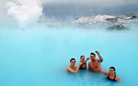
Outdoor fun in Iceland
Photo by dailymail.co.uk No copyright infringement intended.  Used for educational purposes only.
#AtoZchallenge


UPDATE:  As I am researching this subject, I make some AMAZING discoveries about my family  history. I did not know much about the ancient ancestors up to this point, other than their names.  I Googled them just for fun --and low and behold-- I get a plethora of rich historical information about famous and brave warriors and kings from which I can now say I am proudly descended!  It's amazing what you can learn about yourself and your family on a whim!  To say I am amazed and overwhelmed is putting it mildly.   I will exploring more about this part of my past on my own time and you can bet you shields that it will be part of my upcoming book this summer!

Thanks for travelling to Iceland with me!


Tuesday, April 2, 2013

B is for Back Roads; Blogging A to Z Challenge

#AtoZchallenge

B IS FOR BACK ROADS


I love Virginia.  Virginia is home.  I've lived many places in my life but none quite so lovely, so peaceful, so downright BREATHTAKING as "my" Virginia.  I live in a magical, rural area between the Appalachian and Blue Ridge Mountains. Here, there are thousands of back roads.  We don't have freeways, expressways, turnpikes or toll roads.  We have "the Interstate" and "all the other roads".  Don't get me wrong, we do have pavement, but life here is slower, friendlier, and gentler.  Reminiscent of days gone by.

(I've included a lot of links in this blog.  Please feel free to click on them if something interests you.  Each link opens in a separate page so you won't lose your place here. If a link is broken or malfunctions, please let me know! I've done my best to test them all out. They aren't wiki pages either, I've tried to find things of real interest to link to.)

Back roads have been a part of my life for as long as I can remember.  There is something magical about cresting a hill, winding around a turn, and seeing things like this: 

#AtoZchallenge
Rolling Hills of Albemarle County, Virginia
March 2013

#AtoZchallenge
Farmland and Hay, Albemarle County, Virginia

#AtoZchallenge
Farmland and Mountains, Albemarle County, Virginia

Albemarle County is the setting for the old TV show, "The Waltons".  Earl Hamner, Jr. wrote the book that was eventually turned into the series.  Earl would have been John-Boy in the show, the one to whom everyone said, "Goodnight".  He is the child that grew up on the show and became the famous author, writing about life on Walton's Mountain (published in real life as "Spencer's Mountain").  If you come here to visit, you can go to the original Walton's Mountain and walk through the Hamner's home.  It's so nice to watch that show and hear them talking about "going down into Charlottesville" and so forth.  Most of the series, sadly, was NOT filmed here on location.  Hollywood may try to copy Virginia, but us locals know our mountains!  Still a wonderful show.


 On one recent drive, I was able to snap a picture of this very cool art studio/gallery by the side of the road. 
#AtoZChallenge
Unique Art Studio, Albemarle County


 I had to pull off the road to grab this amazing twilight photo showing the gorgeous Blue Ridge Mountains near my home.
#AtoZChallenge
Twilight in Crozet Virginia

 Coming down my long and winding gravel driveway, I caught a breathtaking sight of evening fog rolling into the nearby woods.  I snapped this pic and just put a sepia filter on it for added effect.  This is one of my all time favorite photos.
#AtoZChallenge
Evening Fog, Crozet Virginia


This gorgeous lake is not far from my house either.  My friend and I take her dogs out to run and play a lot in the evenings, so I am lucky to capture sunsets and twilight shots like this one, another on my personal favorites:
#AtoZchallenge
Twilight by the Lake, Albemarle County Virginia


Sometimes, you see things that make you get out of the car and walk down the road just to grab a photo, like this historic home that was on the market for sale.  I've forgotten the name of it but it dates back to the 1700s.  I love the stone wall!
#AtoZChallenge
Historic Home for Sale, Crozet Virginia


If you can't tell already, I'm a huge history buff!  (Nerd Girl Alert!)  Living here in Virginia, I am blessed to be surrounded, literally, by history.  This marker honors the birthplace of Meriwether Lewis, of Lewis and Clark fame, who was a personal friend of President Thomas Jefferson.  (Jefferson is a native Virginian and his home of Monticello is a MUST SEE when you come to the area.)
#AtoZChallenge
Birthplace of Meriwether Lewis, Explorer of the West


 Art abounds in Albemarle County and you'll see plenty of unique pieces if you take the back roads.  Things like this:
#AtoZchallenge

Folk Art outside of Artist Cottage, near Crozet Virginia


That piece of folk art was in the yard of this very interesting home near Crozet:
#AtoZchallenge
  Unique Artist Cottage, near Crozet Virginia


More Civil War history here in the mountains of Virginia.  Commemorative sign regarding Stonewall Jackson's war campaign in the Shenandoah Valley.  
#AtoZchallenge


Returning home on a snowy day in March, this is the beauty to which I am greeted:
#AtoZchallenge
My Snowy Road, March 2013

I never get tired of these views...and I hope I never will.

So there you have it...the beauty of taking a back road.  Go out and find your own back roads.  Don't forget to take your camera.  You'll be glad you did!

#AtoZchallenge

All photos taken by Tammy Petry.
Dog photographed by permission of owner.